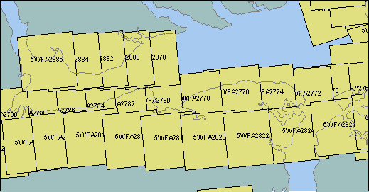
West end of Albemarle Sound
| Image ID | Year | Scale | Azimuth | Latitude | Longitude
| 5WFA2770 | 1990 | 50000 | 264.4 | 35.9703 | -75.9690 | Alligator River mouth
| 5WFA2772 | 1990 | 50000 | 264.4 | 35.9647 | -76.0113 | Little Alligator River mouth
| 5WFA2774 | 1990 | 50000 | 264.4 | 35.9680 | -76.1034 | Little Alligator River
| 5WFA2776 | 1990 | 50000 | 264.4 | 35.9671 | -76.1869 | South shore of Albemarle Sound, west of Alligator River
| 5WFA2778 | 1990 | 50000 | 264.4 | 35.9557 | -76.2820 | Columbia
| 5WFA2780 | 1990 | 50000 | 264.4 | 35.9510 | -76.3795 | West part of Bull Bay
| 5WFA2782 | 1990 | 50000 | 264.4 | 35.9441 | -76.4657 | South shore of Albemarle Sound, west of Bull Bay (Rt 37 Bridge is in photo)
| 5WFA2784 | 1990 | 50000 | 264.4 | 35.9392 | -76.5405 | South shore of Albemarle Sound, west of Rt 37 Bridge
| 5WFA2786 | 1990 | 50000 | 264.4 | 35.9315 | -76.6109 | South shore of Albemarle Sound, Mackeys
| 5WFA2788 | 1990 | 50000 | 264.4 | 35.9257 | -76.6806 | Roanoke River Delta
| 5WFA2810 | 1990 | 50000 | 264.4 | 35.8687 | -76.6793
| 5WFA2812 | 1990 | 50000 | 264.4 | 35.8774 | -76.6071
| 5WFA2814 | 1990 | 50000 | 264.4 | 35.8816 | -76.5298
| 5WFA2816 | 1990 | 50000 | 264.4 | 35.8787 | -76.4344
| 5WFA2818 | 1990 | 50000 | 264.4 | 35.8760 | -76.3399
| 5WFA2820 | 1990 | 50000 | 264.4 | 35.8776 | -76.2443 | Columbia, west is up
| 5WFA2822 | 1990 | 50000 | 264.4 | 35.8813 | -76.1391
| 5WFA2824 | 1990 | 50000 | 264.4 | 35.8898 | -76.0283 | Alligator River Bridge (south is up)
| 5WFA2826 | 1990 | 50000 | 264.4 | 35.9037 | -75.9272
| 5WFA2848 | 1990 | 50000 | 264.4 | 35.7289 | -76.2027
| 5WFA2878 | 1990 | 50000 | 264.4 | 36.0365 | -76.3894
| 5WFA2880 | 1990 | 50000 | 264.4 | 36.0358 | -76.4532 | Snug Harbor to rt 37 bridge
| 5WFA2882 | 1990 | 50000 | 264.4 | 36.0342 | -76.5175 | North shore of Albemarle Sound, Rt 37 Bridge
| 5WFA2884 | 1990 | 50000 | 264.4 | 36.0321 | -76.5779 | Edenton and east
| 5WFA2886 | 1990 | 50000 | 264.4 | 36.0328 | -76.6405 | Edenton and west
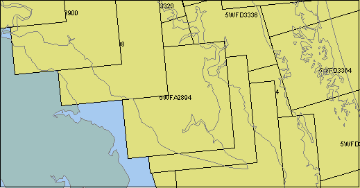
| 5WFA2890 | 1990 | 50000 | 264.4 | 36.1935 | -75.9371
| 5WFA2892 | 1990 | 50000 | 264.4 | 36.2193 | -75.9723
| 5WFD3324 | 1990 | 50000 | 162.6 | 36.1931 | -75.9700 | Camden Pt, North River
| 5WFD3326 | 1990 | 50000 | 162.6 | 36.1314 | -75.9489 | Camden Pt, North River
| |
East end of Albemarle Sound, north side
| Image ID | Year | Scale | Azimuth | Latitude | Longitude
| 5WFA2868 | 1990 | 50000 | 264.4 | 36.3842 | -75.8820 | 5WFA2888 | 1990 | 50000 | 264.4 | 36.1600 | -75.8881 | 5WFA2890 | 1990 | 50000 | 264.4 | 36.1935 | -75.9371 | 5WFA2892 | 1990 | 50000 | 264.4 | 36.2193 | -75.9723 | 5WFA2894 | 1990 | 50000 | 264.4 | 36.2337 | -75.9999 | 5WFA2898 | 1990 | 50000 | 264.4 | 36.2872 | -76.0830 | 5WFA2900 | 1990 | 50000 | 264.4 | 36.3184 | -76.1411 | 5WFA2902 | 1990 | 50000 | 264.4 | 36.3611 | -76.2108 | 5WFD3318 | 1990 | 50000 | 166.5 | 36.3939 | -76.0431 | 5WFD3320 | 1990 | 50000 | 166.0 | 36.3253 | -76.0222 | 5WFD3322 | 1990 | 50000 | 162.5 | 36.2600 | -75.9958 | 5WFD3324 | 1990 | 50000 | 162.6 | 36.1931 | -75.9700 | 5WFD3326 | 1990 | 50000 | 162.6 | 36.1314 | -75.9489 | 5WFD3330 | 1990 | 50000 | 333.4 | 36.0894 | -75.8325 | 5WFD3332 | 1990 | 50000 | 345.0 | 36.1620 | -75.8661 | 5WFD3334 | 1990 | 50000 | 345.1 | 36.2392 | -75.8914 | 5WFD3336 | 1990 | 50000 | 345.1 | 36.3167 | -75.9169 | | Coinjock south - ICW |
| 5WFD3338 | 1990 | 50000 | 345.1 | 36.3939 | -75.9425 | Coinjock north - ICW | ||||||||||||||||||||||||||||||||||||||||||||||||||||||||||||||||||||||||||||||||||||||||||||||||||||||
| 5WFD3366 | 1990 | 50000 | 163.3 | 36.1867 | -75.7731 |
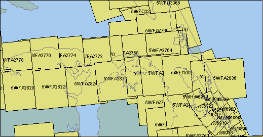
East end of Albemarle Sound, south side - and outer banks
| Image ID | Year | Scale | Azimuth | Latitude | Longitude
| 5WFA2734 | 1990 | 50000 | 264.4 | 36.0162 | -75.8792 | 5WFA2736 | 1990 | 50000 | 264.4 | 35.9639 | -75.8594 | 5WFA2738 | 1990 | 50000 | 264.4 | 35.8968 | -75.8281 | 5WFA2740 | 1990 | 50000 | 264.4 | 35.8375 | -75.7866 | 5WFA2742 | 1990 | 50000 | 264.4 | 35.7760 | -75.7531 | 5WFA2744 | 1990 | 50000 | 264.4 | 35.7162 | -75.7145 | 5WFA2748 | 1990 | 50000 | 264.4 | 35.7100 | -75.6292 | 5WFA2750 | 1990 | 50000 | 264.4 | 35.7443 | -75.6471 | 5WFA2752 | 1990 | 50000 | 264.4 | 35.8298 | -75.6925 | 5WFA2756 | 1990 | 50000 | 264.4 | 35.9621 | -75.7444 | 5WFA2758 | 1990 | 50000 | 264.4 | 35.9920 | -75.7609 | 5WFA2760 | 1990 | 50000 | 264.4 | 36.0366 | -75.7852 | 5WFA2762 | 1990 | 50000 | 264.4 | 35.9846 | -75.7489 | 5WFA2764 | 1990 | 50000 | 264.4 | 35.9823 | -75.7740 | 5WFA2768 | 1990 | 50000 | 264.4 | 35.9754 | -75.8879 | 5WFA2770 | 1990 | 50000 | 264.4 | 35.9703 | -75.9690 | 5WFA2772 | 1990 | 50000 | 264.4 | 35.9647 | -76.0113 | 5WFA2774 | 1990 | 50000 | 264.4 | 35.9680 | -76.1034 | 5WFA2776 | 1990 | 50000 | 264.4 | 35.9671 | -76.1869 | 5WFA2820 | 1990 | 50000 | 264.4 | 35.8776 | -76.2443 | 5WFA2822 | 1990 | 50000 | 264.4 | 35.8813 | -76.1391 | 5WFA2824 | 1990 | 50000 | 264.4 | 35.8898 | -76.0283 | Alligator River bridge - Top of photo is south | 5WFA2826 | 1990 | 50000 | 264.4 | 35.9037 | -75.9272 | 5WFA2828 | 1990 | 50000 | 264.4 | 35.9176 | -75.8254 | 5WFA2830 | 1990 | 50000 | 264.4 | 35.9192 | -75.7747 | 5WFA2832 | 1990 | 50000 | 264.4 | 35.9204 | -75.6969 | Manteo - Top of photo is south west | 5WFA2834 | 1990 | 50000 | 264.4 | 35.9083 | -75.6005 | 5WFA2836 | 1990 | 50000 | 264.4 | 35.9051 | -75.5536 | 5WFA2846 | 1990 | 50000 | 264.4 | 35.7038 | -76.1172 | 5WFA2848 | 1990 | 50000 | 264.4 | 35.7289 | -76.2027 | 5WFA2888 | 1990 | 50000 | 264.4 | 36.1600 | -75.8881 | 5WFD3324 | 1990 | 50000 | 162.6 | 36.1931 | -75.9700 | Broad Creek at south end of North River (ICW) | 5WFD3326 | 1990 | 50000 | 162.6 | 36.1314 | -75.9489 | 5WFD3328 | 1990 | 50000 | 326.0 | 36.0322 | -75.7850 | South end of Currituck Sound | 5WFD3330 | 1990 | 50000 | 333.4 | 36.0894 | -75.8325 | South end of Currituck Sound | 5WFD3332 | 1990 | 50000 | 345.0 | 36.1620 | -75.8661 | 5WFD3366 | 1990 | 50000 | 163.3 | 36.1867 | -75.7731 | 5WFD3368 | 1990 | 50000 | 163.3 | 36.1131 | -75.7461 | Roanoke Sound Bridge | 5WFD3370 | 1990 | 50000 | 163.3 | 36.0397 | -75.7192 | Collington Harbor & north | 5WFK4780 | 1990 | 20000 | 151.6 | 35.9517 | -75.6445 | 5WFK4782 | 1990 | 20000 | 102.9 | 35.9206 | -75.6233 | 5WFK4784 | 1990 | 20000 | 158.6 | 35.8981 | -75.5839 | 5WFK4786 | 1990 | 20000 | 159.3 | 35.8650 | -75.5678 | 5WFK4788 | 1990 | 20000 | 158.6 | 35.8317 | -75.5520 | 5WFK4790 | 1990 | 20000 | 158.6 | 35.7983 | -75.5361 | Oregon Inlet - north side - bridge incomplete | 5WFK4792 | 1990 | 20000 | 159.3 | 35.7653 | -75.5200 | Oregon Inlet - south side - bridge incomplete | 5WFK4800 | 1990 | 50000 | 156.6 | 35.9200 | -75.6358 | Roanoke Sound Bridge and Roanoke harbor | 5WFK4802 | 1990 | 50000 | 156.7 | 35.8328 | -75.5892 | Roanoke Sound south of bridge | 5WFK4804 | 1990 | 50000 | 156.5 | 35.7453 | -75.5428 | Oregon Inlet | 5WFR3143 | 1991 | 20000 | 156.0 | 35.8256 | -75.5808 | 5WFR3145 | 1991 | 20000 | 155.6 | 35.7919 | -75.5653 | Oregon Inlet - north side - bridge complete | 5WFR3147 | 1991 | 20000 | 159.3 | 35.7731 | -75.5547 | Oregon Inlet - bridge complete | 5WFR3149 | 1991 | 20000 | 152.8 | 35.7547 | -75.5453 | Oregon Inlet - south side - bridge complete | 5WHW6896 | 1992 | 20000 | 330.1 | 35.7639 | -75.5196 | Oregon Inlet - south side - nice shadow of bridge | 5WHW6898 | 1992 | 20000 | 324.2 | 35.7944 | -75.5397 | Oregon Inlet - north side - nice shadow of bridge | 5WHW6900 | 1992 | 20000 | 318.5 | 35.8195 | -75.5594 | 5WHW6902 | 1992 | 20000 | 322.7 | 35.8454 | -75.5825 | 5WHW6904 | 1992 | 20000 | 153.1 | 35.8454 | -75.6157 | Roanoke Island - south end | 5WHW6906 | 1992 | 20000 | 138.0 | 35.8165 | -75.5978 | 5WHW6908 | 1992 | 20000 | 145.7 | 35.7948 | -75.5748 | North of Oregon Inlet - nice view of sand bars | 5WHW6912 | 1992 | 20000 | 148.5 | 35.7416 | -75.5318 | 5WHW6916 | 1992 | 20000 | 329.0 | 35.7525 | -75.5695 | 5WHW6918 | 1992 | 20000 | 313.3 | 35.7799 | -75.5898 | 5WHW6920 | 1992 | 20000 | 319.3 | 35.8029 | -75.6142 | 5WHW6922 | 1992 | 20000 | 322.7 | 35.8268 | -75.6355 | Roanoke Island - south end | 5WHW6924 | 1992 | 20000 | 333.6 | 35.8523 | -75.6542 | |