Swinging Ship - Making a Compass Deviation Table
|| Dan's Home Page
| Pyxis Home Page
||
This page is still under development....
 Deviation
Deviation is the difference between a boats magnetic heading and compass heading. Compasses are intended to point to magnetic north. Because of metal components on the boat (engine, batteries, keel, ballast) the compass may deviate from magnetic north. A correction for this error is required to calculate a proper course. The problem is complicated a bit further because the deviation will vary depending on the boats heading. It may be 5 degrees east when heading 100 mag and 5 degrees west when heading 280 mag. To be able to make proper corrections on any heading a table of deviations is needed.
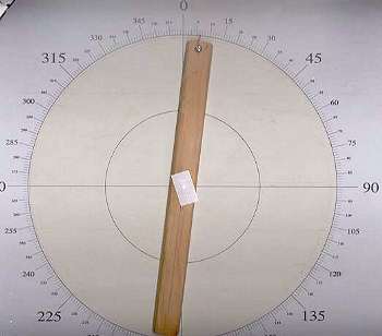
I have made a deviation table for my P26. I used a home made pelorus type device to measure the relative sun angle and recorded compass heading, relative sun angle and time. Knowing these along with lat and long you can calculate the deviation by finding the true sun angle at the time of the sight.
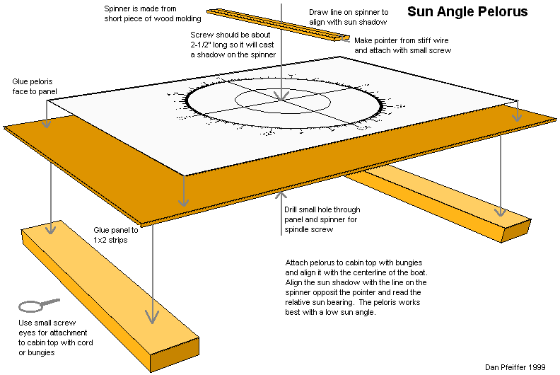
Pelorus Diagram
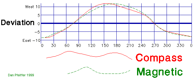
Plot of Measured Deviation (before compass adjustment)
Finding the Sun Azimuth
I have a couple of methods to find the sun azimuth. I wrote a program for my HP-41 calculator that can find the sun azimuth (and any of the other navigation stars and planets). I need to input the time and location. I also have a few computer programs from which I can get azimuth. My favorite is GeoClock. This is the best shareware program I have ever seen. It plots a night/day line (terminator) on any of about 300 maps of the earth. It plots the sun and moon positions and does lots of other fascinating things. Well worth the price of admission ($20-$40?). I also have a few different astronomy programs including EZ Cosmos and LodeStar. Each of these methods requires that you know your location within about 1 mile. that's pretty easy to do. You can get it from a GPS or LORAN or you can get it off the chart.
You can also get the sun azimuth for any location on the planet at any time from the US Naval Observatory's excellent web site. You can only enter your location to within 1 minute of latitude and longitude but that will probably be good enough.
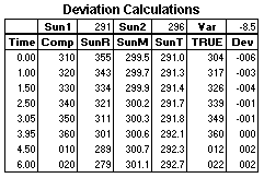 You only need to find the azimuth for the first and last observation then you can interpolate for the ones in between. I set it up in a spread sheet. The azimuth gives you a true bearing to compare the compass bearing to. You can get the local variation from your chart (I figure you have a chart because if you are the sort that doesn't you won't give a squat about correcting your compass). The true heading is the sun azimuth - the sun relative bearing. Add the variation to this to get the magnetic heading. Compare this to the compass heading to get the deviation. It's really pretty simple, you just have to be careful to keep track of the angles.
GeoClock Website
US Naval Observatory sun azimuth data page
I have PDF versions of a pelorus face that you can print to make your own and a deviation worksheet. The pelorus face is set up to print at 11x17[1].
PDF of Pelorus Face
Compass Deviation Worksheet
[1]To print the pelorus face at 8.5x11 select Shrink to Fit from the Print dialog box of the Adobe Acrobat Reader.
>>DAN'S HOME PAGE<<
What do you think of my WWW pages?
Email me with you comments.
dan@pfeiffer.net
Copyright ©1999 Dan Pfeiffer
